Wednesday, January 30, 2013

Goggle Update

Snow goggles, a little farther along.
I've been making some slow progress on the snow goggles. Last Friday, I got hit by this flu that's been going around the province and lost the weekend and the first half of this week. I've slowly been getting back into a work routine, but I'm still not 100 percent. I was very grateful for the two Plans and Profiles interviews that showed up in my inbox on Friday and Monday mornings so that I wouldn't have to think about blog topics on those days.

Spruce, with narrow triangular eye slits
The goggles on the left are the ones that I'm making for the Ontario order. They are based on the Wapusk National Park goggles that I was asked to reproduce for Park's Canada in 2010. They are nearly done here, I just have to braid some artificial sinew for the straps. In these photos, they are threaded with cotton twine to test them out, but I want to give them a more natural look.  The artificial sinew is a good visual match for real sinew but will be a little more durable, as the client requested.


This is the original artifact and the reproduction pair that I made in 2010.  The original goggles are very dried out and in some places its tough to tell what elements were part of the design and what changes happened to the goggles through weathering.  The eye slits on the artifact are actually narrow triangles, rather than flat rectangular slots. This may be a result of weathering or it may have been part of their design.  In 2010, I made rectangular eye slots, but this time around, I'm going with more triangular slits.

 Photo Credits: Tim Rast

Monday, January 28, 2013

Plans and Profiles: Chelsee Arbour Researching Quartz use at Kamestastin, Labrador

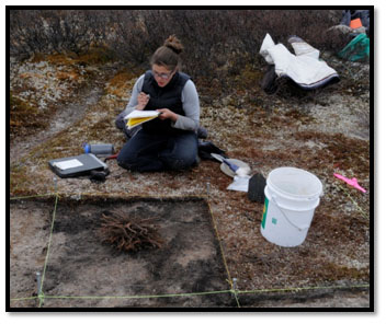
Chelsee Arbour writing notes at Tshetshuk,
 one of the sites we excavated in the
2012 spring season.
Photo by Dr. Stephen Loring.
Chelsee Arbour's archaeological research has led her to Kamestastin, in the interior of northern Labrador. As a PhD candidate in the Department of Archaeology at Memorial University of Newfoundland, she is examining quartz use during the archaic period at Kamestastin.  I asked Chelsee if I could interview her because I'm interested in the area and her work and she was recommended by Amelia Fay, (the subject of the first Plans and Profiles interview) as one of the people that she would like to see profiled.  Chelsee sent back some very thoughtful answers that trace her ongoing research journey.

Plans and Profiles #4. Chelsee Arbour, Quartz use at Kamestastin, Labrador


1) Tell me a little about your project

My research is part of a larger collaborative project with the Tshikapisk Foundation, an Innu non-profit cultural heritage organization, and the Arctic Studies Center of the Smithsonian Institution. For a number of years, these two organizations have jointly undertaken a long-term archaeological and cultural-heritage research initiative at Kamestastin. Kamestastin is a meteor impact crater lake located in the heartlands of the Mushuau Innu and the interior barrenlands of the Innu homeland, Nitassinan (Labrador/Northern Québec). Over the last decade, 260 sites and find-spots have been located in the Kamestastin region, suggesting continuous – albeit episodic – occupation in the area from the Tshiash Innu[1]/early Maritime Archaic to contemporary times. Personal experiences, oral histories and oral traditions that have been passed on over uncounted generations, a deep abiding relationship with the caribou and an ingrained familiarity with Nitassinan have all contributed to relationship between the Mushuau Innu and the land. In this way, the sites and find-spots found on the land are tangible traces of the Mushuau Innu ancestors and part of the larger narrative of Nitassinan.

My role in this project will be to investigate the numerous and predominantly quartz assemblages of some of the earliest occupations at Kamestastin. Quartz use is very common during this period, however, a dedicated analysis of this material – how it is used and what it can tell us about movement, acquisition, human-land relations and social life-ways in general – has yet to receive the same attention in Northeast Atlantic archaeology as other types of raw material. In addition to the detailed analysis of these quartz assemblages, my research will seek to determine how, and to what extent, the multiple narratives associated with the use of quartz and people’s relationship to Kamestastin (including oral histories, personal experiences and archaeology) overlap, change and evolve through time. Thus, the underlining foundation of my PhD research will be focused on developing and maintaining a multi-vocal research design that implicates the Mushuau Innu in the process of writing the past.

Caribou crossing the Kamestastin narrows during the fall migration south. Photo taken by Valerie Courtois

2) How did you become interested in this particular problem? 

Before starting my PhD, my research had been focused on hunter-gatherer-fisher peoples at the cusp of or shortly after shifting to an agricultural way of life in a variety of European contexts. I was especially interested in how this agricultural influence affected the interaction between people, landscape and material goods. In my M.A. research, I investigated site location choice and visibility as components of monument placement during the Neolithic and Bronze Age in West Penwith, Cornwall, England. I attempted to find common ground between quantitative analyses conducted in GIS and qualitative observations using phenomenological frameworks of field survey in an effort to merge two different ways of accessing the past, albeit both within an archaeological framework. While I found that each contributed in different ways to the discussion of visibility and site location during these periods, I also recognized that how I was using these two frameworks failed to resolve the tension that underlines their irreconcilability. This lead me to seriously question how the past in understood and constructed, and what information is left unsaid when a single narrative is focused on at the expense of others. In a way, this questioning had always been part of my research interests, but following my M.A. it solidified on unpacking different ways in which in the past is reconstructed, reimagined and remembered at both an archaeological and an individual level. In my mind, any geographic context is composed of multiple narratives, in which archaeology is just one way of engaging with the past. As I was thinking about all of these different things – landscape, social life-ways, multiple narratives, quantitative vs. qualitative – I began to wonder about the Northeast Atlantic. This musing brought me here to Newfoundland and to Labrador.

View of the Tshumushumapeu valley, located on the south side of the Kamestastin narrows. Picture was taken by Dr. Stephen Loring facing west.


3) Has your project changed since you originally began working on it? How?

When I first got to MUN, my ideas about what I wanted to do were consciously very open ended, and extremely broad. I knew I was interested in the earliest people of Labrador/Québec, my ideal was to work in the interior because I was fascinated by what had been found, and convinced there was more in the interior than what little had been recovered. I was also very keen to work on a community based project where multi-narratives would be an ongoing part of the research. Originally, I suggested a project focused on the interrelationship between site location, artifacts and the underlying social life-ways of the Maritime/Labrador Archaic in Labrador, with a specific focus on establishing the context (topographic, economic, ecological, symbolic, etc.) of Archaic site location choice. I was interested in how the social life-ways are created through the interaction between people, places and things, but I was also interested in how narratives are created in the present by the people who are constantly walking in the land and interacting with these sites. About a year and a bit after I came to MUN, I started working with the collaborative project at Kamestastin, which fit perfectly with what I hoped to do and has since expanded beyond all of my expectations.

Anthony Jenkinson, Chelsee Arbour and Vise Grips on the way to the Shak Selma site, spring 2012. Photo taken by Dr. Stephen Loring.

4) If you could ask the people/person who lived at your site one question what would it be? 


Crystal and smokey quartz flakes. The bottom three are 
crystal quartz and top six are smokey quartz.
I’ve thought about this a lot, especially when I was snowshoeing around Kamestastin last spring. Honestly, I think I changed my mind about what I would ask every week. At the moment I think I would have to ask “Where did you get your crystal and smokey quartz and what were you making out of it?”. I know that’s actually two questions, but…they’re related! We have this amazing and perfectly translucent quartz which looks like natural glass and seems to be popular during the earliest occupation phases, but for the most part we only have the flakes. We recently found a few unifacially worked flakes that resemble microblades but so far no complete tools have been recovered. I am quite interested to know what they are doing with this material and where they are getting it. There are potential sources in the area surrounding Kamestastin that I hope to take samples from this coming season, but I have a feeling that the crystal quartz is not coming from the same place as the other high quality veined quartz found in these early assemblages…I could be wrong, but it’s my gut feeling.


5) Have you ever found anything in the field or in the lab that you wish you hadn’t?

No, although I have found some unexpected specimens. We just recently did a flotation on the hearth contents from one of the early sites at Kamestastin and were pleasantly surprised (to put it mildly) to find sea urchin shell, a mouth piece and spines amongst the calcined bone. The specimens have been burned, which suggests that the sea urchin was exploited and deliberately discarded at the time the hearth was in use. Kamestastin is approximately 130km from the coast today, and even with considering the landscape change that has occurred over the past 5000 years, people would still have had to travel a great distance to bring sea urchin into the Kamestastin area. This opens up a whole area of inquiry about coastal and interior human-land-animal relationships that is unexpected but fascinating.


6) Why did you choose Memorial University of Newfoundland (MUN)? 

A black bear coming to visit on 
a snowy day at Kamestastin.
By the time I started writing applications for my PhD, I was set on Labrador. I did apply to other schools, but I was already seriously considering MUN after a long discussion with my M.A. supervisor, Dr. James Conolly from Trent University. I wanted to work with my current supervisor, Dr. Peter Whitridge, because our areas of interest overlap quite a bit. I am glad I have been given that opportunity because he has been supportive, critical and free with advice. There were also many professors in the department whose work I was interested in; Dr. Mario Blaser, Dr. Lisa Rankin and Dr. Priscilla Renouf in particular, all three of whom have taken the time on multiple occasions to talk with me about my project and future directions. The entire archaeology faculty is fantastically knowledgeable and dedicated to Northeast Atlantic archaeology, many with a long-term connection to research in Labrador. There’s also a phenomenal library with great resource material, and the school is quite close to the PAO (the Provincial Archaeology Office) and the ROOMS museum – all of which are fantastic resources for research in the province. For someone interested in Newfoundland and Labrador archaeology, MUN is really the best choice.


7) How do you unwind when you need to get away from your research?

That is a good question. I volunteer with the St. John’s Soccer Association, which has been very helpful in taking my mind off my work.  I find it very fulfilling, even though I am only with the team half the season because of field work. Outside of soccer, I am currently trying to change some of my habits, so I don’t have a set unwinding technique anymore. I used to watch ‘popcorn’ TV, light fluffy comedies that didn’t have anything to with what I was working on. Now I’m trying a few new things, although I do fall back on some of my favorite light shows. I tried knitting, but it’s not the best option for me. I like it, but my wrists really do not. It’s a little embarrassing walking around with a wrist brace from a knitting session – I do blame the PhD and the typing that accompanies it. I am also trying to get back into reading for fun – no articles or text books allowed! So far, I am so relaxed from 15 minutes of fun reading that I have no trouble getting to bed at a decent time…I’ll let you know when I find something that I stick with for a bit.


8) There’s a lot of travelling and writing in archaeology. Any tips in either category?

Two things: you can never have enough underwear and bring warm clothes/sleeping equipment. Lots of underwear means less laundry days. I have a bit of a reputation about laundry – I absolutely hate it. I do not know why, but I simply cannot stand doing it. There is a point where it absolutely has to be done, and I never push it until I resemble pig pen from the peanuts, but in my mind as long as you have clean underwear, you are good to go. And the second piece of advice would be never choose entertainment over warmth. If you don’t have enough to read, at least you can do other things; talk with people, explore, catalogue, sing to yourself, sleep. If you’re anything like me, sleep is next to impossible if you’re cold, which also means it is going to be a long season. As for the travel, archaeologists have this fantastic opportunity to see and explore places that are simply inaccessible in a tourist capacity. Even bad conditions make amazing adventure stories in retrospect.

Anthony Jenkinson and Dr. Stephen Loring pushing a canoe filled with digging gear towards the end of the 2012 spring season after the ice started to open up and the skidoo was retired.

9) What publications or websites would you recommend if people want to learn more about your area of interest in general? Or your project in particular?

I’ve touched on a lot of different topics in this interview: quartz, Kamestastin, the Tshiash Innu/Maritime Archaic, Mushuau Innu, identity and narrative construction, landscape archaeology, phenomenology, GIS. There is an extensive literature on each one of these areas, except perhaps quartz  tools. The most recent literature that I have come across on quartz tools is Understanding Quartz Technology in Early Prehistoric Ireland (2010) by Killian Driscoll. For an overview on landscape archaeology, which touches on Phenomenology and GIS, I would suggest The Handbook of Landscape Archaeology (2008). I often refer to it for overviews on different landscape related topics as well as for the extensive bibliography. I would recommend going to the Innu Nation website which has a fantastic reference page with numerous papers and books relating to Innu heritage for anyone wanting to learn more www.innu.ca. Another great resource is www.nametauinnu.ca . There are a number of significant publications on identity and narratives, but one of the books that had a profound effect on me is Reports from a Wild Country: Ethics for Decolonisation (2004) by Deborah Bird Rose. At the time that I read it, I was struggling to articulate my discomfort solely engaging with single narratives and it continues to help me work through some of the issues that arise when interacting with multiple narratives. There are so many articles, books and theses available on the Maritime Archaic and the development of Amerindian culture in Labrador that it is really difficult to pick just one to suggest. To suggest something would depend on what the person is interested in: earliest sites, regionalization, mortuary contexts, etc.

The term Tshiash Innu was first used by the Tshikapisk Foundation/Arctic Studies Center collaborative as both a way in which to mitigate against unnecessary confusion and disassociation during cultural-heritage programs at Kamestastin and as a reference to the possibility of cultural connections between the earliest Amerindian peoples of Labrador/Québec and the present day Innu. As for the work at Kamestastin, the two people I work with the most on this collaboration are Anthony Jenkinson (of the Tshikapisk Foundation) and Dr. Stephen Loring (of the Arctic Studies Center). They have both published numerous papers on the ongoing archaeological and cultural-heritage research over the years, which are referred to in the reference section of this interview.

For more information on the Tshikapisk Foundation, you can go to www.tshikapisk.ca

For more information on some of the previous collaborative work at Kamestastin, you can visit www.kamestastin.com

As for my own work, I have not written much that has been published just yet, but there is a co-authored PAO newsletter article coming out soon which describes our 2012 spring field season that I (shamelessly) recommend to anyone who wants to know more about this project. I also am happy to talk further should anyone be interested and can be contacted at csa413@mun.ca


References 

David, B. and J. Thomas (eds).
2008 The Handbook of Landscape Archaeology (eds) Bruno David and Julian Thomas. Left Coast Press, Walnut Creek.
 

Driscoll, K.
2010 Understanding Quartz Technology in Early Prehistoric Ireland. Unpublished dissertation. University College Dublin, Dublin.


Jenkinson, A.
2011 Summary of Tshikapisk Excavations at Kamestastan 2008 To 2010. In Provincial Archaeology Office Review Volume 9 for 2010 Field Season.


Loring, S.
1992 Princes and Princesses of Ragged Fame: Innu Archaeology and Ethnohistory in Labrador. PhD dissertation, Department of Anthropology, University of Massachusetts/Amherst.

1997 On the trail to the Caribou House: some reflections on Innu Caribou hunters in northern Nitassinan (Labrador). In, Caribou and Reindeer Hunters of the Northern Hemisphere (eds) Lawrence Jackson and Paul Thacker. Pp. 185-220. Avebury: Aldershot (Great Britan).

2001 Archaeology with the Innu at Kamestastan. Arctic Studies Centre Newsletter 9:10-11. National Museum of Natural History, Smithsonian Institution.

2005 Smithsonian fieldwork in Labrador, Summary of 2004 fieldwork. Provincial Archaeology Office Newsletter 3: 20-21.

2006 Smithsonian research in Labrador, Summer 2005. Provincial Archaeology Office Newsletter 4: 55-60.

2008 At home in the wilderness: the Mushuau Innu and caribou. In The Return of the Caribou to Ungava, A.T. Bergerud, Stuart Luttich and Lodewijk Camps. Pp. 123-134. McGill-Queen’s University Press: Montreal.

2009 From tent to trading post and back again: Smithsonian anthropology in Nunavut, Nunavik, Nitassinan, and Nunatsiavut – the changing IPY agenda, 1882-2007. In Smithsonian at the Poles: Contributions to International Polar Science (eds) Igor Krupnik, Michael A. Lang, and Scott E. Miller. Pp. 115-128. Washington: Smithsonian Institution Scholarly Press.


Loring, S. and A. Jenkinson
2009 The Trail to the Caribou House: A Tshikapisk Archaeological and Cultural Heritage Initiative. Fieldwork in the Vicinity of Border Beacon at the Labrador-Québec Boundary in Nitassinan. Arctic Studies Centre Newsletter 16: 38-9.

2012 Tshikapisk Foundation; Archaeological Research in 2011. In Provincial Archaeology Office Review Volume 10 for 2011 Field Season. 


Loring, S., A. Jenkinson and E. Pastiwet
2009 Caribou Country Archaeology: Tshikapisk sponsored Research in Nitassinan, fall 2004. Report on File at the Provincial Archaeology Office, Government of Newfoundland and Labrador.


Loring, Stephen, Moira McCaffrey, Peter Armitage and Daniel Ashini
2003 “The archaeology and ethnohistory of a drowned land: Innu Nation research along the former Michikamats lake shore in Nitassinan (interior Labrador)”. Archaeology of Eastern North America 31:45-72.


Rose, Deborah Bird
2004 Reports from a Wild Country: Ethics for Decolonisation. University of New South Wales Press Ltd, Sydney.


[1] Translates to “old Innu from long, long ago”.


==============================================

Is there someone that you would like to see profiled here?  Perhaps your'd like to raise awareness of your own research?  Contact elfshot.tim@gmail.com.

Photo Credits: As listed in the photo captions

Friday, January 25, 2013

Plans and Profiles: Lisa Daly Researching WWII Airplane Crash Sites in Newfoundland

Lisa Daly exploring the inside of an 
A-20 Havoc recovered outside 
of Goose Bay, Labrador. 
Photo property of Lisa M. Daly
Lisa Daly is a PhD student in Archaeology at Memorial University of Newfoundland, here in St.John's.  In this edition of Plans and Profiles, I asked her about her ongoing PhD research into WWII related sites in Newfoundland and Labrador and early 20th century aviation disasters in the Province.  Her research has taken her on a very personal journey and led to many surprising discoveries and meetings along the way.


Plans and Profiles #3. Lisa Daly, World War II Aviation Archaeology in Newfoundland and Labrador


1. Tell me a little bit about your project. 

Maryanne Baird surveying the RCAF Canso site 
in Gander, NL. Photo by Lisa M. Daly.
My PhD project centers on World War II in Gander, Newfoundland and Labrador. I am looking at airplane crash sites in the area, researching the accidents and inventorying what remains in the archaeological record. As well, I am also looking at how the sites were created, including the initial crash, subsequent rescue/recovery of the site, and later site use up to the present day (as trail markers, tourism attractions, sources of scrap material, potential restoration projects, etc.). I am also looking at some of the Former Town Site of Gander. In 2011, I lead a team who excavated some of the Globe Theatre, the theatre on the Canadian side of the airbase, mostly to look at the interactions of the different countries (Canadian, American, British and of course, Newfoundland) on the airbase.

Coke bottle fragment recovered from the 
Globe Theatre in Gander, NL. 
Photo by Courtney Merner.
Beyond my thesis work, I have also been working in other areas of early aviation in Newfoundland and Labrador. I assisted in the recovery of an A-20A Havoc from outside Goose Bay, and am currently working on the research of a 1946 American Overseas Airlines (AOA) civilian crash near Stephenville; at the time it was the largest civilian aviation disaster in the world. The site was rediscovered (it had been lost for a few decades), recorded, and now research and video work is being done in the hopes of releasing a documentary about the event in the next year or two. Similarly, I have assisted in the research of the Hindenburg over Newfoundland, mostly by finding and contacting individuals around the island who remember seeing the dirigible or have photographs. Dr. Michael Deal just released a paper featuring some of this and I hope to release a short documentary about the Hindenburg's Newfoundland connection featuring this research. The paper is "Airships over Newfoundland" in the Canadian Aviation Historical Society Journal, volume 50, number 1.

At the Globe Theatre, we excavated so much Coke bottle glass that we decided to stop and take a Coke break. From left to right: Dr. Mike Deal, Kathleen Ellwood, Chelsee Arbour, Lisa Daly and Shannon Green. Photo by Shannon K. Green.

2. How did you become interested in this particular problem?

Uncovering silver aircrew wings
 from the B-24 Liberator site, 
in Gander, NL. Photo by Lisa M. Daly
It stated in 2007. I had just earned my MSc in Forensic and Biological Anthropology from Bournemouth University, UK, and was looking for archaeological work for the summer. I applied for a few positions, but Dr. Deal's project sounded the most interesting. He was going to be excavating a WWII crash site just outside of Gander, and most relevant to my Master's work, there were still three individuals listed as MIA on the site. The site was a B-24 aircraft that had crashed on 14 Feb 1945, killing all 10 men on board. I thought it would be a great opportunity to use my physical anthropology knowledge in the field. We did find one fragment of human remains, and the proper US authorities have been informed, but what really captured my passion was finding personal effects on the last day of the dig. A historian who was visiting the site, Darrell Hillier, pointed out a button as he was walking through the site. I dug around the button and found it was attached to a jacket. Along with the jacket were other personal items such as more buttons, pins, zippers, chains, and most powerful, a couple of house keys. That really made the site interesting, the idea that these keys would have been used when this individual went home again. A couple of months later myself, Dr. Deal and a number of volunteers returned to the site and excavated that area. It was determined that this was where their luggage had landed so we were finding clothing, elements from kit bags, and even a set of silver navigator's wings. After researching the site, a name and picture could be put to those wings. As part of this project, I also had the opportunity to meet the pilot's son. He visited St. John's and Gander in 2009. After his visit to Gander, he thanked the archaeological team because almost 65 years after his father died he felt that he finally had closure and understood what happened. 

Uncovering a house key at the B-24 Liberator site in Gander, NL. Photo by Lisa M. Daly


3. Has your project changed since you originally began working on it? How?

Breaking for lunch. The ground was so wet that the only 
place to sit was on the RCAF Lodestar, in Gander, NL. 
From left to right: Eric Guiry and Kathleen Ellwood. 
Photo by Lisa M. Daly.
My project has changed a little. Initially, the focus was not going to be just on the crash sites. There were plans for excavation work around the runway and the Former Town of Gander. But, there were problems with a lot of that plan as Gander is still an active airport, making around the runway and the American side of the base off limits, and there are a number of environmental hazards and continuous testing for ground contamination in that area. I had a number of grand plans for excavation, including some of the dump and the remains from a hangar fire that occurred in 1943, but these areas were deemed off limits. At this time, I was also realizing just how much information the crash sites could give, and how much documentation was available, so the crash sites became a much larger part of the project.


4. What's the one question about your research that you never want to hear again?

Volunteer Missy Cousins uncovering aircraft 
fragments at the RCAF Canso site. 
Don't worry, she has permission. 
Photo by Lisa M. Daly.
"I'm going hiking this weekend, can you tell me where that site you went to is, I'd love to see it."

I'm not the best hiker in the world, but I don't like to share the exact location of sites if I don't think people are really prepared for them. The best preserved sites are in the most remote locations and a number of precautions need to be taken. There might be unexploded ordinance on these sites, you may need military permission to access them, you may have to cross a kilometer or more of bog, scale a cliff face covered in rubble, or it might be contaminated by fuel or other hazardous materials and none of them have clear trails. I wouldn't want someone who is not used to bushwhacking to attempt these sites, or who is not adequately prepared for the hazards to be injured. In these cases I do try to encourage people to visit more accessible sites, such as the B-17 on the trails in the Thomas Howe Demonstration Forest in Gander, or the B-36 crash in Burgoyne's Cove, near Clarenville, that features a steep, but well maintained trail to access the site.

The memorial and some of the wreckage at Burgoyne's Cove; note Random Island in the distance. This is an accessible site that is actually located in Nut Cove, but generally called the Burgoyne's Cove crash. For more information and directions on how to visit this site, check out http://www.thetelegram.com/Motoring/2008-11-05/article-1454933/Hike-into-History/ Photo by Lisa M. Daly. 


5. What advice do you have for students considering archaeology?

Lisa inside a section of a Ferry Command 
Ventura that crashed between Gander 
and Benton, NL. This section of fuselage 
had been cut away from the rest of the 
aircraft and transported it about 200 
metres from the main crash site. 
Photo by Michael Deal.
Talk to and volunteer with an archaeologist. There is certainly some adventure that goes along with archaeology, if adventure includes falling in bogs, and lots of sweat and dirt. It's not always easy to know what goes in to archaeology unless you do it, from research to lab work to field work. I have known people who have acquired their archaeology degree only to find they detest field work! Certainly take the first year class, see if there is an area that interests you, but also use the resources available to see if it's a good match. Whenever I teach the first year course, I ask MUNArch, the archaeology society, to give a talk. They are a great resource for anyone and will offer students information on volunteer opportunities, both in the lab and the field, and their mixers are a great way to chat with archaeologists. The best way to pick an archaeologist's brain is to offer to buy them a drink, then question away!


6. Why did you choose Memorial University of Newfoundland (MUN)?

Newfoundland 50 cent coin recovered from
 the Globe Theatre in Gander, NL. 
Photo by Lisa M. Daly.
I'm from St. John's, so MUN was the obvious place for me to go for my undergrad. When I was offered a chance to apply to MUN to do a graduate project based in Newfoundland I jumped at the chance. I have always loved my province (I have been working as a tour guide since 2002), and studying in the UK just enhanced that love. Added to that, between the QEII Library, the Center for Newfoundland Studies, the AC Hunter Library, the Gander Public Library and the Provincial Archives, most of my documentary research could be done at home. The bit I needed from the National Archives of Canada could be accessed through inter-library loan.

The best part about choosing MUN is just how much more of the province I have seen because of this work. I have seen some beautiful sights in Gander, reconnected with some of my family on the West Coast, and had the privilege of working on a project in Labrador. I stayed in Goose Bay for 10 days and loved every moment of it. I can't wait to go back.


7. How do you unwind when you need to get away from your research?

Lisa visiting a Cold War crash site, an RB-45C, near
 Goose Bay, Labrador. Photo by David Hebbard.
By always staying busy. I love to be doing something all of the time. So if I'm not actively working on my PhD or one of my aviation side projects, then I am learning how to ballroom dance, or bowling in a league, or playing board games and D&D with friends, or selling comic books, or making new cosplay outfits (usually videogame or steampunk related), or working as a tour guide, or reading for pleasure and for my monthly book club. And with all that, sometimes it's nice to just sit on the couch with my cats, pour up a glass of whiskey and play some video games with my boyfriend.

Actually, I don't think I know how to unwind. I drove across the island this past summer to go to my cousin's wedding in Stephenville, camp in Gros Morne and visit L'Anse aux Meadows, and what did I do but collect stories and images of the Hindenburg and conduct a brief archaeological survey of crash high on a cliff face, sparking another large project!


8. If your thesis had a soundtrack, what would be on it?

Pepsi bottle fragment recovered from the
Globe Theatre in Gander, NL.
Photo by Courtney Merner.
 The Andrews Sisters. I love jazz and big band, and The Andrews Sisters have to be my favourite. I'm actually designing a dieselpunk cosplay outfit based on their typical USO outfits. Besides that, it's usually rock and roll (even more so since learning how to jive) and classic rock. Sometimes I feel bad for my assistants and volunteers for having to listen to "old" music, and other times I feel even worse for them because I like to sing along! I'm always happy when they sing along with me.

Movie film recovered from the Globe Theatre site in Gander, NL. Photo by Lisa M. Daly

9. What books or websites would you recommend if people want to learn more about your area of interest in general? Or your project in particular?

There are some wonderful resources out there about different aspects of Newfoundland's aviation history. Thinking mainly of the WWII era, I would suggest Ocean Bridge by Carl A. Christie or Pathfinder by Donald C.T. Bennett, both about the origins and history of RAF Ferry Command. RCAF and USAAF histories are a little harder to find, and much more technical (and dry) in their writings, but the best is probably W.A.B. Douglas' The Creation of a National Air Force, in particular the Ferry Command appendix in Vol. II. Base Colonies of the Western Hemisphere, 1940-1967 by Steven High is a great look at the interactions between the American forces setting up bases and the locals and has a very interesting chapter on Newfoundland. For Newfoundland and the war, check out Peace of the Continent by Malcolm MacLeod, or for more personal stories, Best of Aviation by Frank Tibbo or A Friendly Invasion (parts I and II) by John N. Cardoulis.

For my project in particular, well, I guess your best resource would be http://mun.academia.edu/LisaMDaly. I try to keep it updated with my most recent publications, presentations and interviews. For information on one of my side projects, The Telegram did an article called "The Forgotten Crash" about the work being done in Stephenville.

A dinner tray recorded on the 1946 AOA civilian crash near Stephenville, NL. Photo by Shannon K. Green.
==========================================================

If you would like to see your research, or that of a friend, student, or colleague, profiled here, please get in touch with me at: elfshot.tim@gmail.com.


Photo Credits: As listed in the photo captions.

Wednesday, January 23, 2013

Working on Wood Snow Goggles

Spooky...
I'm working on a few pairs of snow goggles this week.  I have an order for one pair of goggles for a hands-on museum exhibit in Ontario.  I think the I'll probably send them a new pair of the Wapusk snow goggles that I've made and talked about before.  But while I'm working on those, I wanted to try reproducing some snow goggles that we found on Baffin Island during a survey in 2010.  The Baffin Island goggles are the ones in the photos in this blog post.


Claude is recording the goggles where we found them lying on the ground.

One of the guys we worked with said that his grandfather from Pond Inlet had a pair just like this.  They are big and round and look like owl eyes.

To start the reproductions I printed 1:1 photos of the goggles to use as patterns and split a  3 1/2" diameter spruce log down the middle to create the half-round blanks to begin with.  I don't have the original goggles to refer to, but I believe this should give a pretty good match to the wood grain in the artifact.


For most of the coarse shaping, I use a sanding disc on an angle grinder.

I stop frequently to refer to the reference material and plan my next series of cutting or grinding.

For the finer shaping, I switch to the dremel tool.  A coarse sanding drum works for a lot of the details, like the hollows around the eye slits on the inside of the goggles.

I don't cut out slots for the eye holes. The originals were probably whittled and gouged out by hand with a sharp knife.  I'll switch to sharp knife for the final finishing and to leave the appropriate tool marks on the finished reproduction, but even with the dremel tool, the principle is the same.  I'm slowly gouging down, deeper into the wood until it becomes paper thin and the eye slits emerge.  I think you can see in above the side-by-side comparison with the reference material that this is how the slits were made in the original.
Photo Credits: Tim Rast

Monday, January 21, 2013

Snowshoeing the East Coast Trail

Silver Head Mine Path
Lori and I used some Christmas money to buy snow-shoes this year and we finally hit on the perfect weekend to test them out on the East Coast Trail.  The weather cooperated with fresh snow falling on Friday and Saturday nights, but with crisp blue skies during the day on both Saturday and Sunday. Breaking through new snow on even the best marked path makes you feel like a proper explorer.
The Blackhead Path - Cape Spear to Blackhead

View of the Cape Spear Lighthouse
from along the Blackhead Path
On Saturday, I drove out to Cape Spear and hiked along the Blackhead Path to the top of Blackhead, back towards St. John's.  The road to Cape Spear starts at the bottom of our street, so I really don't have an excuse to not visit more often.  I parked at the main lot and walked back along the barrens towards the small parking lot along the road where the trail head is marked and the path to Blackhead technically begins.  The trail goes through coastal barrens, woods, and up to the top of Blackhead.  It continues on to the community of Blackhead and ultimately Fort Amherst in St. John's, but I turned around at the summit.  The hike was a little less than 3 hours at a pretty leisurely pace (I took over 200 photos).  There was some thigh high drifting at the top of Blackhead, but for the most part it was a pretty comfortable hike.

The view back towards Cape Spear from Blackhead. 


Returning to Cape Spear


On a clear day, you can easily see Signal Hill from Cape Spear and Blackhead.

Cape Spear

Silver Head Mine Path - Middle Cove to Torbay

Mouth of Motion River/North Pond River 
On Sunday, we headed to Middle Cove and hiked the Silver Head Mine Path north towards Torbay.  People had hiked and snowshoed the trail on Saturday, but we had a few centimetres of new fresh powder all to ourselves.  The path starts at Middle Cove beach, quickly ascends a steep wooded cliff with a vertical drop into the Atlantic and continues along the cliff edge towards Torbay.  There are two areas of running water along the trail - the first we met was Houlihan's River, which was small enough to jump over, but a few hundred metres from the path end at Torbay there is a larger river, called either Motion River or North Pond River.  We turned around at this river and made our way back to Middle Cove.  The hike took around two hours.


Heading back towards Middle Cove. (Click to Enlarge)


Looking down into Middle Cove
The mouth of Houlihans River.  The trail skirts through the woods along the the top of the cliff in the background.
There was no way to get across the river in snowshoes, so we turned around at this point.  Its was definitely worth the trip.
Motion River/North Pond Rive enters the Atlantic in this cove.

Photo Credits:
1-10,12,13: Tim Rast
11: Lori White
Related Posts with Thumbnails